Abstract
This analytical paper presents the DREVO Coastal Green Corridor concept as a modular nature-based engineering system for stabilizing mobile sands, protecting coastal infrastructure, and establishing resilient vegetation cover in arid coastal regions of Morocco. The project combines four core components: fog-harvesting structures, wind and biological barriers, soil engineering, and phased selection of drought- and salt-tolerant plant species.
The project should be viewed not as decorative landscaping, but as an infrastructure adaptation measure for arid coastal environments. Its practical value lies in reducing road sand encroachment, lowering maintenance costs, increasing the resilience of roadside areas to wind and heat, creating local employment, and developing a replicable model for further scaling.
The proposed starting format is a 5-15 km pilot section in a coastal area affected by ocean fog, wind-driven sand movement, and limited access to freshwater. The pilot phase is estimated at 18-24 months. The preliminary budget estimate is EUR 40,000-90,000 per km, excluding potential cost reductions from scale, local procurement, and standardized implementation.
Keywords: coastal desert, green corridor, fog harvesting, sand fixation, biological barrier, desertification, Morocco, Dakhla-Oued Ed-Dahab, climate adaptation, nature-based solutions.
Introduction
Arid coastal territories of North-West Africa are characterized by a combination of low rainfall, high evaporation, wind erosion, mobile sand deposits, salt aerosols, and limited freshwater availability. Under such conditions, conventional greening approaches based on continuous irrigation and water-demanding species are expensive and fragile.
At the same time, coastal zones possess a resource that is often underestimated in engineering planning: humid ocean air and recurring fog. With an appropriate technical design, this resource can provide supplementary moisture for vegetation establishment and microclimate formation. The DREVO Coastal Green Corridor is based on this logic: rather than importing water indefinitely, the project aims to create a system that gradually increases the landscape's ability to retain moisture, reduce wind speed, and stabilize sand.
This document converts the initial project draft into an analytical concept suitable for preliminary discussion with academic, infrastructure, governmental, and research institutions. It does not replace engineering surveys, botanical assessment, environmental review, or local permitting, but it provides a structured basis for pilot design.
1. Project Relevance
1.1. Infrastructure Problem
Wind-driven sand movement creates a constant burden on transport infrastructure in coastal and desert regions. Sand encroachment reduces road safety, requires regular mechanical cleaning, increases operating costs, and shortens the service life of adjacent infrastructure elements. If protection relies only on mechanical removal, the problem remains chronic: sand is removed from the road, but the source of movement is not stabilized.
A green corridor along a road should be treated as a preventive infrastructure measure. Its role is not only to create vegetation, but also to change the conditions of sand transport: reducing near-surface wind speed, increasing surface roughness, accumulating organic matter, improving topsoil moisture, and forming a root network.
1.2. Environmental Problem
Desertification and wind erosion in arid regions intensify when natural vegetation cover is degraded. Loss of vegetation reduces moisture retention, raises surface temperatures, increases sand mobility, and degrades the soil horizon. As a result, the land loses its capacity for self-recovery.
The proposed model is designed to initiate the reverse process: first, mechanical and biological sand fixation is established; then a primary soil layer is formed; finally, more complex plant communities are introduced. This approach follows the logic of degraded land restoration: from surface stabilization to ecosystem development.
1.3. Socio-Economic Significance
The project has practical value for regional development. Its implementation can involve local contractors, nurseries, manual soil-work teams, monitoring services, and educational institutions. Unlike capital-intensive infrastructure projects, the green corridor can be launched modularly and expanded gradually.
The social effect includes job creation, transfer of practical skills in arid-land greening, development of local competence in nature-based engineering, and reduced dependence on external suppliers during scale-up.
2. Goal, Objectives, Object, and Subject of Study
2.1. Goal
The goal of this work is to develop an analytical concept for the DREVO Coastal Green Corridor pilot in Morocco's arid coastal territories, based on the integration of fog-water harvesting, sand stabilization, soil engineering, and phased introduction of resilient plant species.
2.2. Objectives
2.3. Object and Subject
The object of study is Morocco's arid coastal territory exposed to wind-driven sand movement, salt aerosols, and freshwater scarcity.
The subject of study is a nature-based engineering system for creating a linear green corridor that combines fog-harvesting structures, wind-biological barriers, soil stabilization, and adapted planting.
3. Methodological Basis
The work is based on a project-analytical approach. The initial concept is assessed through four interconnected levels: natural, engineering, biological, and managerial.
The natural level includes wind, salt aerosols, fog, sand movement, and moisture scarcity. The engineering level includes fog collectors, micro-relief, stone lines, organic material cells, planting basins, and micro-catchments. The biological level includes plant selection based on tolerance to salt, drought, wind, and poor soils. The managerial level defines pilot stages, budget, metrics, responsible parties, and scale-up procedures.
The document uses preliminary numerical parameters from the original project draft. These parameters should be treated as indicative and must be refined through field surveys, cost estimates, botanical expertise, and consultations with local authorities.
4. Project Concept
4.1. General Idea
DREVO Coastal Green Corridor is a linear green protection system along a coastal road or other infrastructure line. The pilot section may cover 5-15 km, while the basic module is 50-100 m. Modularity allows testing on a limited territory, comparing different combinations of plant species and engineering elements, and then scaling the most successful solutions.
The system can be described as follows: humid ocean air and fog enter the coastal zone; fog collectors and plant surfaces condense part of the moisture; soil elements slow runoff and evaporation; plants stabilize sand through roots; biomass and mulch increase organic matter; the established cover reduces wind speed and protects the road.
Thus, the project functions as a system of cumulative small effects. Each element has limited value on its own, but their combination can change the microenvironment of the site.
4.2. Difference from Conventional Greening
Conventional greening in dry climates often depends on permanent irrigation. In such a model, plants remain dependent on external water, and interruption of irrigation can lead to planting failure. DREVO proposes a different approach: start-up irrigation is used as a temporary measure, while the main goal is to increase the autonomy of the plant system.
The key difference is that survival conditions are created first: wind protection, sand fixation, micro-catchments, mulch, organic matter, and fog-water collection. Only then are species requiring a more stable microclimate introduced.
5. Basic Module Architecture
- The 50-100 m basic module should be designed as a multilayer system.
5.1. Layer A: Fog-Harvesting Line
The first layer consists of fog collectors 2-3 m high, placed at intervals of 10-20 m depending on wind regime, terrain, and fog density. Their functions are:
- collecting part of the moisture from fog;
- reducing wind speed;
- creating a primary humid zone;
- providing experimental data on actual water yield.
At the pilot stage, fog collectors should be treated not only as a water source but also as a measurement tool. Data on collected water will support decisions on further scaling.
5.2. Layer B: Wind-Biological Barrier
The second layer consists of 1-2 rows of salt- and drought-tolerant woody and shrub species. The original draft identifies Tamarix aphylla and Acacia tortilis as base options. Additional candidates may include Casuarina equisetifolia, Atriplex halimus, Ziziphus spp., Balanites aegyptiaca, and other species, subject to confirmation by local specialists.
- The main functions of this layer are:
- reducing near-surface wind speed;
- trapping transported sand;
- protecting inner zones from salt aerosols;
- creating shade and a primary microclimate;
- accumulating organic material.
Preliminary spacing is estimated at 3-5 m for woody forms and should be adjusted based on actual survival rates.
5.3. Layer C: Soil Engineering
- The third layer consists of low-cost mechanical and organic elements:
- 1 x 1 m cell structures made from straw, branches, or local biomaterial;
- stone lines perpendicular to the prevailing wind;
- planting basins and micro-catchments around plants;
- mulch from organic residues;
- localized compost application in planting zones.
The purpose of this layer is to reduce sand mobility, retain moisture, protect root zones, and create conditions for soil material accumulation. This is particularly important during the initial phase, when plants have not yet formed sufficient root mass.
5.4. Layer D: Understory and Herbaceous Cover
The fourth layer includes shrubs, saltbushes, grasses, and groundcover species. Its role is to fill the space between woody elements, bind the upper sand layer with roots, reduce surface overheating, and accelerate organic horizon formation.
At the early stage, preference should be given to species capable of tolerating salt, wind, poor soils, and irregular moisture. Food or ornamental crops should be introduced only in the second phase, after microclimate stabilization.
6. Water Model
6.1. Water Sources
The project should not depend on a single source of moisture. During the pilot stage, the following sources may be combined:
- Limited start-up irrigation during the first 6-12 months.
- Fog-water collection using mesh structures.
- Moisture condensation on plant surfaces.
- Local micro-catchments for retaining water near roots.
- If technically feasible, a pilot solar desalination unit or transported water for critical establishment phases.
The original concept provides an indicative value for a 100 m module: 100-300 liters per day during start-up, followed by a reduced need. This figure must be refined according to planting density, temperature, evaporation, soil type, and selected species.
6.2. Logic of Reducing Irrigation
In the first months, irrigation serves to launch the system. After plants root, mulch accumulates, and sand stabilizes, the need for external water should decline. The planned logic is:
- 0-6 months: limited regular irrigation and survival monitoring;
- 6-12 months: irrigation reduction, planting correction, strengthened mulching;
- 12-24 months: transition to a maintenance regime, with priority on fog moisture and soil water retention.
If actual water demand does not decrease, this indicates a need to revise species selection, planting density, or site engineering.
7. Territorial Zoning
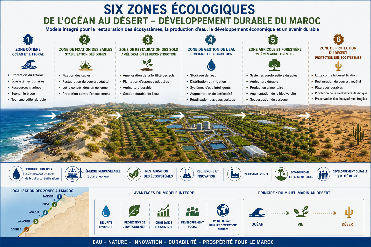
For a coastal desert zone, gradient zoning from the ocean inland is recommended. The original project draft considers a five- or six-zone model. For the analytical pilot, a six-zone model is proposed.
7.1. Zone 1: Direct Ocean Exposure
Approximate distance: 0-30 m from the area of maximum ocean influence or strong salt aerosol exposure.
- Conditions: extreme salt, wind, abrasive sand impact, and high substrate instability.
- Purpose: primary protection and fixation, without sensitive crops.
Plant groups: Tamarix spp., Atriplex spp., Suaeda spp., and Casuarina equisetifolia if suitability is confirmed.
7.2. Zone 2: Salt Barrier
- Approximate distance: 30-80 m.
- Conditions: high but reduced salt load, strong wind, poor soil.
- Purpose: formation of a protective biological barrier and sand trapping.
Plant groups: Tamarix, Atriplex, Acacia/Vachellia, and local shrubs tolerant to salt and drought.
7.3. Zone 3: Transition Zone
- Approximate distance: 80-150 m.
Conditions: moderate salt load, remaining wind impact, potential for gradual organic matter accumulation.
- Purpose: expansion of species composition and creation of shrub and herbaceous cover.
Plant groups: Acacia tortilis, Ziziphus spp., Balanites aegyptiaca, Atriplex halimus, and drought-tolerant grasses.
7.4. Zone 4: Inner Protective Zone
- Approximate distance: 150-300 m.
- Conditions: lower salt, more stable microclimate, improved potential for soil development.
- Purpose: development of resilient green cover, biodiversity enhancement, and shade formation.
Plant groups: acacias, ziziphus, balanites, and selected fruit or forage species after verification.
7.5. Zone 5: Microclimate Zone
- Distance: 300 m and beyond, or areas protected by the established biological barrier.
- Conditions: reduced wind, lower salt aerosol exposure, higher soil moisture.
- Purpose: testing second-stage crops, including fruit, forage, and soil-improving plants.
Plant groups: pomegranate, fig, date palm, grapevine, mulberry, and other drought-tolerant crops only where the water model is confirmed.
7.6. Zone 6: Experimental and Production Zone
This zone is optional. It may be located in the most protected part of the site and used for a nursery, composting, test beds, seedling acclimatization, and monitoring.
Its function is to supply planting material, reduce future scale-up costs, and create a training platform for local specialists.
8. Planting Strategy
8.1. Species Selection Principles
- Plant selection should be based on:
- drought tolerance;
- tolerance to salt aerosols;
- ability to grow on poor sandy soils;
- deep or branching root systems;
- ability to reduce wind speed;
- availability of planting material;
- absence of high invasive risk;
- compliance with local ecological requirements.
Prosopis juliflora and related species require particular caution. Although drought-tolerant, they are considered potentially invasive in several regions. Their use should be allowed only after consultation with local environmental authorities.
8.2. Stage One: Stabilization
Stage one uses plants capable of performing an engineering function. Their purpose is not fruit production or decorative value, but survival under harsh conditions and modification of the microenvironment.
- Base groups:
- Tamarix spp. for salt-tolerant wind and salt barriers;
- Atriplex spp. for saline and poor soils;
- Acacia/Vachellia spp. as drought-tolerant woody forms with deep root systems;
- Casuarina equisetifolia as a potential windbreak species, subject to suitability confirmation;
- local grasses and groundcover species for upper-layer fixation.
8.3. Stage Two: Soil Formation
After primary sand fixation, species that increase organic mass, create shade, and improve soil structure are introduced. This stage relies on shrubs, forage grasses, soil-forming herbaceous species, compost, mulch, and controlled organic inputs.
The objective is to build a soil matrix in which the next level of vegetation can survive more reliably.
8.4. Stage Three: Productive Crops
Fruit and food crops should not form the basis of the initial phase. They are introduced only after a protected microclimate is established. Potential test species include Punica granatum, Ficus carica, Ziziphus mauritiana, Phoenix dactylifera, Vitis vinifera, and other drought-tolerant crops.
Their introduction should remain experimental and limited. The main criterion is not maximum yield, but confirmation that productive greening is possible in the protected zone.
9. Soil, Compost, and Biological Restoration
Sandy substrate is not a complete soil by itself. Stable vegetation requires conditions for organic matter accumulation, moisture retention, and microbial development.
- Recommended elements:
- compost pits or piles in protected zones;
- use of seaweed after washing and salt control;
- dry organic matter in planting basins;
- surface mulching;
- stones for reducing evaporation and creating micro-shade;
- localized biomaterial application instead of uniform treatment of the entire area.
The key principle is not to attempt to turn the whole area into fertile soil immediately. A localized approach is more rational: first improve planting points and barrier lines, then gradually involve the spaces between them in restoration.
10. Pilot Implementation Plan
10.1. Pilot Scale
The recommended starting scale is a 5-15 km coastal section. This size is sufficient for useful data collection while avoiding excessive financial burden. If successful, the pilot can be expanded to 5 km, 10 km, and beyond.
10.2. Timeline
Total pilot duration: 18-24 months.
| Stage | Period | Main actions |
|---|---|---|
| Stage 1. Preparation | 0-3 months | Site selection; measurement of wind, salt, fog, and sand mobility; module layout; procurement of mesh, poles, and planting material; preparation of cell structures, stone lines, and micro-catchments. |
| Stage 2. Planting launch | 3-6 months | Installation of fog collectors; planting the first biological barrier rows; start-up irrigation; mulching; initial survival monitoring. |
| Stage 3. Adjustment | 6-12 months | Replacement of dead plants; analysis of actual fog-water collection; irrigation reduction where survival is sufficient; reinforcement of weak zones; testing additional species. |
| Stage 4. Evaluation and scaling | 12-24 months | Comparison of experimental modules; assessment of sand encroachment before and after implementation; calculation of maintenance cost; preparation of a scale-up decision; development of a repeatable methodology. |
11. Performance Metrics
For presentation to governmental and academic institutions, the project requires measurable evaluation indicators:
| Metric | Measurement |
|---|---|
| Reduction of sand encroachment | cm/month, removed sand volume, cleaning costs |
| Soil moisture | Percentage moisture at control points and depths |
| Plant survival | Percentage of living plants by species and zone |
| Fog-water collection | Liters/day per collector and per module |
| Surface temperature | Change in shaded and unshaded soil temperature |
| Near-surface wind speed | Comparison before and after barriers |
| Organic matter content | Soil analysis at control points |
| Economic effect | Change in road cleaning and site maintenance costs |
| Social effect | Number of local jobs and share of local materials |
Metrics should be measured not only at the end, but throughout the pilot. This allows errors to be identified before they become systemic.
12. Financial Model
12.1. Preliminary Budget per 1 km
The original concept proposes the following cost structure for 1 km of pilot section:
| Cost item | Indicative estimate |
|---|---|
| Fog-harvesting mesh and poles | EUR 15,000-30,000 |
| Plants and planting work | EUR 10,000-20,000 |
| Soil works, cells, stones, manual teams | EUR 5,000-15,000 |
| Start-up irrigation and logistics | EUR 5,000-15,000 |
| Monitoring and management | EUR 5,000-10,000 |
| Total | EUR 40,000-90,000/km |
These values are preliminary. Official submission requires a local cost estimate reflecting material prices, seedling availability, labor costs, logistics, equipment rental, and monitoring requirements.
12.2. Economic Logic
The economic value of the project appears in three areas:
- Reduction of direct costs for cleaning roads and adjacent facilities from sand.
- Reduction of infrastructure damage risk and operational interruptions.
- Creation of a scalable model that may become cheaper through local production of mesh, seedlings, compost, and soil-stabilization elements.
At the pilot stage, the financial objective is not immediate payback, but proof of model functionality and collection of data for larger-scale calculations.
13. Organizational Model
- The project can be presented to several groups of institutions:
- authorities responsible for agriculture, irrigation, and land restoration;
- authorities responsible for transport infrastructure and roads;
- forestry and environmental agencies;
- regional coastal authorities;
- universities and research centers;
- international programs on desertification control and climate adaptation.
- The optimal submission format is not one large document, but a package of three materials:
This analytical paper can serve as the basis for the second document and as an attachment to the pilot proposal.
13.1. Governance Principles
- The project governance system should be based on:
- sustainable development;
- transparency of financial and operational reporting;
- scientific justification of engineering and ecological decisions;
- participation of local communities;
- adaptive management based on monitoring results.
13.2. Governance Structure
- For the pilot, a multi-level governance structure is recommended.
The Steering Committee is responsible for strategic decisions, budget approval, project expansion, major partnerships, and institutional reporting.
The Technical Advisory Board provides engineering, ecological, and scientific expertise. It should include hydrologists, ecologists, agronomists, renewable-energy specialists, soil scientists, and university representatives.
The Project Management Unit is responsible for daily coordination: procurement, schedule, contractor agreements, reporting, logistics, infrastructure maintenance, and implementation of Steering Committee decisions.
Local Operational Teams carry out planting, fog-collector maintenance, irrigation control, greenhouse and nursery care, field data collection, minor repairs, and primary plant monitoring.
13.3. Decision-Making System
Strategic decisions are made by the Steering Committee. These include pilot expansion, budget changes, territory changes, new partners, and transition from experiment to scale-up.
Technical decisions are made based on Technical Advisory Board recommendations. These include species selection, planting design changes, fog-collector adjustments, monitoring protocols, and water regulations.
Operational decisions are made by the Project Management Unit. These include maintenance schedules, procurement of consumables, team allocation, replacement planting, and routine logistics.
13.4. Stakeholders
- Key stakeholder groups include:
- public authorities: environmental agencies, regional authorities, water agencies, agricultural and infrastructure bodies;
- scientific institutions: universities, research centers, environmental laboratories;
- local communities: workers, farmers, cooperatives, educational organizations;
- private sector: engineering companies, renewable-energy suppliers, nurseries, environmental technology companies;
- international partners: organizations working in climate adaptation, land restoration, water resilience, and desertification control.
14. Scaling to a 5 km Pilot
Additional project materials propose considering not only a minimum 5-15 km format, but also a managed 5 km pilot. This scale requires operational infrastructure: nurseries, greenhouses, reservoirs, water distribution, compost nodes, and maintenance systems.
14.1. Active Managed Strip
For 5 km, it is not rational to fully develop the entire depth from the ocean inland at once. A more realistic model focuses active work selectively in zones 2-5, where protective barriers, soil formation, nursery capacity, and future productive areas are established.
The preliminary estimate for the active managed area in the first phase of a 5 km section is 75-150 ha. The remaining territory is initiated through softer methods: terrain shaping, grasses, barrier lines, mulching, and limited irrigation in key nodes.
14.2. Nurseries and Greenhouse System
- For a 5 km pilot, a dedicated nursery block is recommended. Working reference values:
- 20-30 greenhouses in the standard model;
- 24 greenhouses as a balanced starting option;
- 16 main semi-underground greenhouses and 8 small hardening greenhouses;
- approximate greenhouse area: 448 m2.
Semi-underground greenhouses are useful for reducing overheating, protecting seedlings from wind, acclimatizing planting material, and reducing water demand.
14.3. Water Balance for the 5 km Pilot
The additional material proposes three water-demand scenarios:
| Scenario | Water, m3/day | Water, m3/year |
|---|---|---|
| Minimum | 16 | 5,840 |
| Working | 25-30 | 9,125-10,950 |
| Intensive | 45-50 | 16,425-18,250 |
The working scenario requires approximately 25-30 m3/day. This should not be supplied only by desalination. A more resilient system combines solar desalination, fog collectors, occasional rainfall, reservoirs, micro-relief, mulch, compost, and strict irrigation limits.
14.4. Infrastructure for 5 km
- For the working 5 km scenario, the following may be required:
- 200-300 m3 of water storage for 7-10 days;
- 20-50 fog-harvesting nodes if fog is confirmed;
- 30-60 small desalination modules or an equivalent combined water system;
- 200-400 compost pits or 50-100 compost trenches;
- a main water-distribution line along the section with branches to active modules;
- soil-preparation area, mulch storage, seedling hardening zone, and seaweed-processing node.
The key conclusion is that solving the project through water alone would make it expensive and vulnerable. Resilience comes from combining water, terrain, soil, shade, mulch, wind barriers, and correct planting sequence.
15. Risk Management System
Risk management is carried out in four stages: risk identification, probability and impact assessment, mitigation planning, and continuous monitoring. Risks should be reviewed at each pilot stage because an arid coastal system responds quickly to errors in water, planting, wind protection, and maintenance.
15.1. Environmental Risks
| Risk | Probability | Impact | Mitigation |
|---|---|---|---|
| Extreme drought | High | High | Phased planting, drought-tolerant species, water reserve, adaptive irrigation |
| Sand advance | High | High | Stabilizing mesh, dune barriers, pioneer plants, micro-relief |
| Salt accumulation | Medium | High | Salinity monitoring, drainage, controlled irrigation, salt-tolerant species |
| Biodiversity disturbance | Medium | Medium | Species diversity, avoidance of invasive species, ecological monitoring |
15.2. Water Risks
| Risk | Probability | Impact | Mitigation |
|---|---|---|---|
| Insufficient water production | Medium | High | Multiple water sources, reserve capacity, phased expansion |
| Desalination system failure | Medium | Medium | Modular design, spare parts, system redundancy |
| Increasing groundwater salinity | Medium | High | Observation wells, controlled abstraction, alternative sources |
| Low actual fog-collector yield | Medium | Medium | Preliminary measurements, test collectors, location adjustment |
15.3. Engineering Risks
| Risk | Probability | Impact | Mitigation |
|---|---|---|---|
| Wind damage to infrastructure | High | Medium | Wind-resistant design, reinforced anchoring, regular inspection |
| Degradation of solar equipment | Medium | Medium | Service schedule, protective coatings, cleaning from salt and sand |
| Reservoir or distribution failure | Low-medium | High | Regular checks, reserve tanks, local emergency storage |
| Micro-relief design errors | Medium | Medium | Pilot plots, post-wind-event inspection, correction of sand-retention lines |
15.4. Financial Risks
| Risk | Probability | Impact | Mitigation |
|---|---|---|---|
| Budget overrun | Medium | High | Contingency fund, phased procurement, local materials |
| Financing delays | Medium | High | Diversified funding, reserve maintenance budget |
| Lower-than-expected revenues | Medium | Medium | Conservative model, multiple revenue sources, separation of pilot and commercial phases |
15.5. Operational and Social Risks
| Risk | Probability | Impact | Mitigation |
|---|---|---|---|
| Shortage of qualified staff | Medium | Medium | Training, university involvement, standardized instructions |
| Maintenance delays | Medium | Medium | Service contracts, spare parts stock, inspection schedule |
| Supply disruptions | Medium | Medium | Local suppliers, stock planning, alternative materials |
| Insufficient local participation | Medium | Medium | Jobs, consultations, education programs |
| Stakeholder conflicts | Low-medium | Medium | Transparent communication, approval protocols, independent mediation |
15.6. Compliance System
- Before implementation, requirements must be checked and formalized in the following areas:
- environmental legislation;
- water legislation;
- land-use rules;
- occupational health and safety;
- rules for handling marine biomass and organic materials;
- permits for construction, mesh installation, reservoirs, and temporary greenhouse structures.
15.7. Reporting and Audit
- Recommended reporting schedule:
- monthly: operations, irrigation, maintenance, planting condition, failures;
- quarterly: financial report, environmental monitoring, risk analysis;
- annually: independent audit, ecological assessment, strategic review, scale-up decision.
15.8. Crisis Response Plan
The project should prepare procedures for extreme weather, water shortage, water-infrastructure failure, mass planting loss, fog-collector damage, environmental incidents, and financing delays. A rapid response group should be authorized to reallocate water, repair infrastructure, and temporarily adjust work schedules.
16. Key Performance Indicators
The KPI system should link ecological results, operational stability, economics, and social impact.
- Ecological indicators:
- plant survival by species and zone;
- increase in soil organic matter;
- dune stabilization and reduced sand mobility;
- expansion of vegetation cover;
- surface temperature change.
- Water indicators:
- volume of produced or collected freshwater;
- water-use efficiency per plant or module;
- reliability of water storage;
- share of water obtained from alternative sources;
- reduction in irrigation after rooting.
- Economic indicators:
- cost per 1 km of corridor;
- monthly maintenance cost;
- number of local jobs;
- share of local materials and contractors;
- reduction in infrastructure sand-cleaning costs.
- Social indicators:
- participation of local residents;
- number of trained workers;
- involvement of educational organizations;
- satisfaction of key participants;
- number of partnerships with scientific and civil organizations.
17. Expected Pilot Results
- If successful, the pilot should provide:
- confirmation or rejection of fog-collector effectiveness at the selected site;
- plant survival data by zone;
- reduced sand mobility in experimental modules;
- formation of a primary green barrier;
- actual cost calculation per 1 km;
- scale-up methodology;
- list of suitable species for further use;
- justification for expansion to 5-30 km.
A positive pilot result is not only a fully formed green corridor, but reliable data on which elements work, which require replacement, and which parameters must be changed before scaling.
18. Long-Term Vision: Moroccan Green Line
If pilot effectiveness is confirmed, DREVO Coastal Green Corridor can become the first stage of a broader Moroccan Green Line program. In this format, the project moves beyond a single environmental experiment and becomes a model for long-term development of southern coastal regions.
- Potential scaling path:
- 5-15 km pilot to verify the technology;
- 5 km expanded pilot with nurseries, water infrastructure, and monitoring;
- 30 km demonstration corridor;
- 100+ km long-term perspective, subject to proven effectiveness, financing, and institutional support.
- Strategic directions:
- protection of the Atlantic coast and infrastructure from sand encroachment;
- formation of a network of fog collectors, reservoirs, solar desalination units, and moisture-retention systems;
- creation of a green belt between ocean and desert;
- development of a research center for desert restoration, desalination, seaweed, agroforestry, and climate adaptation;
- creation of ecological routes, demonstration gardens, and educational sites.
This section should be treated as a strategic vision, not as a pilot-stage obligation. It should be included in institutional presentations only after the base model has been verified.
Conclusion
DREVO Coastal Green Corridor is a promising concept for nature-based engineering adaptation of arid coastal territories. Its strength lies in combining simple, testable, and relatively low-cost components: fog collectors, biological windbreaks, localized soil engineering, mulching, start-up irrigation, and phased plant selection.
The key condition for success is to avoid the logic of immediate full-scale greening. In a coastal desert, sand must first be stabilized, the site must be protected from wind and salt, micro-relief must be created, and organic matter must be accumulated. Only then is it realistic to expand species composition and transition to productive or more complex plantings.
For institutional presentation, the project should be positioned as an infrastructure pilot for road protection, maintenance cost reduction, desertification control, and local climate-adaptation modeling. Its scientific value lies in the potential to obtain field data on the interaction of fog collectors, plant barriers, and sandy soils in an Atlantic coastal desert environment.
Recommendations for the Next Stage
Sources and Materials for Scientific Verification
- FAO. Sand dune stabilization, shelterbelts and afforestation in dry zones.
- FAO. Special forest plantations and dune stabilization guidance.
- FAO. Dune fixation: a tool for desertification control.
- UNCCD. World Atlas of Desertification.
- ScienceDirect, 2024. Multi-aspect assessment of operational fog collection systems: Sidi Ifni project in Morocco.
- Wageningen University & Research. Observation-driven model for calculating water-harvesting potential from advective fog in semi-arid coastal regions.
- Fondation Mohammed VI pour la Protection de l'Environnement. Oued Eddahab Bay coastal preservation program.
- Estudos do Quaternario. Aeolian dynamics and dune sands in the Dakhla region, Southern Morocco.
Document Status Note
This text is an English academic version of the revised project draft. Numerical estimates, plant species, water-balance values, and budget parameters are preliminary project references. Before submission to a public authority, university, or research institute, the document requires additional source verification, local cost estimation, field assessment, and confirmation of biological species with relevant specialists.